Great Barrier Reef Timeline
Discover more about the Great Barrier Reef with our history timeline. Our descriptive timeline is partitioned into four historical parts, Geological, Cultural, Western, and GBRs own history.


Image: Coral at Moore Reef
Geological History
Youngest Reef System in the World
The Great Barrier Reef (GBR) is considered the youngest reef system in the world with its earliest beginning around 600,000 years ago and the modern GBR forming only 9,500 years ago. Coral reefs are limestone structures (Calcium carbonate structures) produced by living organisms. The first reef building corals appeared over 500 million years ago, with modern corals or stony corals emerging only 240 million years ago.
So why is the world’s largest coral reef system so young?
The corals that exist today are thought to have evolved in the ancient Tethys Sea between Laurasia and Gondwanaland. As continental drift caused these continents to separate, the Tethys Sea began to close, and the widely dispersed evolving corals were slowly pushed eastward and concentrated in what is now the western Pacific Ocean. This is thought to have contributed to the high diversity of corals in the region today. Today this region contains more than 76% of coral species and is known as the coral triangle. The Coral Triangle is an area of highly biodiverse reef systems located between Indonesia, the Philippines, and Papua New Guinea.
Continental Drift from Pangea to Today
Continental drift also accounts for the late start of the Great Barrier Reef 600 000 years ago. Around 65 million years ago Australia, a rainforest dominated continent, was connected to Antarctica and was positioned further South than its current position. At this time, the continents began to split and Australia drifted North to its current position. Around 20 million years ago Queensland had nearly reached its current position and the continent was drying out and only remnants of the old rainforest were remaining. The extension of the Qld Plateau or continental shelf (long, wide, and shallow) along the coastline provided a perfect stable substrate for corals to thrive. However, corals were not recorded to flourish at this time. Cool water temperatures and poor visibility have been suggested as the main reasons for this.
This changed at ~ 600,000 years ago, the northernmost parts of the Great Barrier Reef began to form as the area was now within a warmer climate. Coral larvae settled on the ocean floor and began to grow. It is also thought that the continental movements allowed the East Australian Current to bring warm water and coral larvae onto the northern parts of the continental shelf, contributing to increasing coral growth.

Sea Levels and Climatic Changes
More recently, the formation of the Great Barrier Reef was driven by Sea Level and Climatic changes. Over the last 500,000 years the reef has developed as sea level has risen and fallen over multiple glacial (ice ages) and interglacial cycles (warmer periods).
In a glacial period as ice forms at polar caps and in glaciers, sea level falls, while in interglacial periods ice melts causing sea level to rise once more. During these cycles sea level could change at a rate up to 5m per thousand years. The difference in sea level between interglacial periods was up to 120m. These differences caused drastic differences in marine habitats. For example, during the ice age around 18,000 years ago, people living in the region where Cairns city is now would have had to travel 60km to reach the coastline. This also meant that Fitzroy Island was part of the mainland.
During periods of high sea level, when the continental shelf was inundated, corals were able to grow in the warm shallow waters and create reefs. During these periods, reefs accumulated at rates more than 10m per thousand years. The formation of the Great Barrier Reef has occurred throughout many such periods of reef growth. It is important to understand that reef growth only occurred during periods where conditions were conducive to coral growth and reef formation. It is estimated that coral’s have only been exposed to conditions suitable for reef formation for ~10% of the ecological time between the last two interglacial periods. The short period in which the Great Barrier Reef formed makes the huge biodiversity even more remarkable.
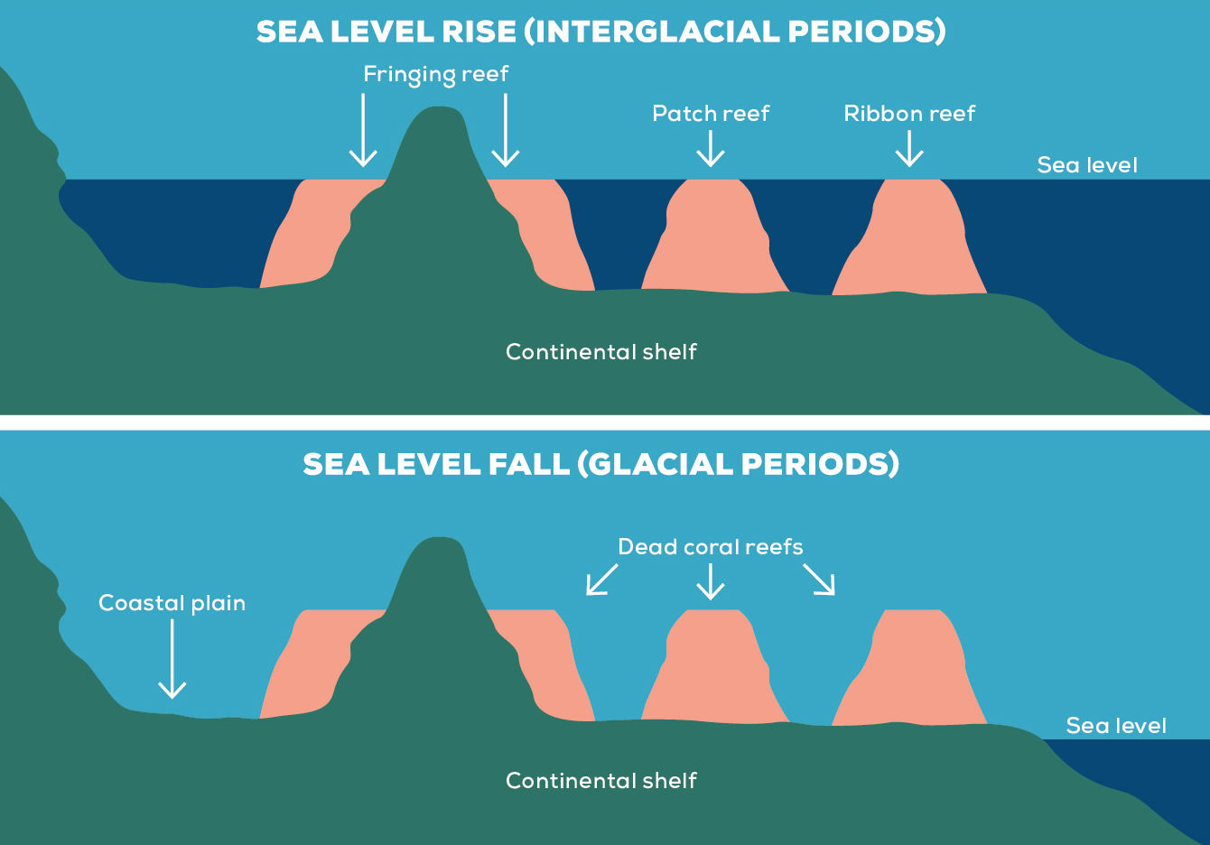
Image: Moore Reef
Image: Green Island
Great Barrier Reef as we know it
The great barrier reef as we know it developed during the last period of sea level rise which began around 9,500 years ago. It is estimated that the primary reef growth began around 9,000 years ago and continued until approximately 4,000 – 5,000 years ago. For the most part, the sea level on the Great Barrier Reef has been relatively stable for the last 6000 years, allowing the Great Barrier Reef to continue developing to what is present today. The geological processes that have isolated populations for thousands of years are probably still in progress today. These factors have driven evolution along with the GBR connection to coral triangle via Torres Straits and are possible explanations why the GBR is one of the most diverse coral reefs in the world.

Cultural History
Oldest Culture in the World
While we may house one of the youngest reefs in the world, we are home to the oldest living culture in the world dating back at least 60,000 years. During this time, the coastline has undergone many changes and there is evidence that Aboriginal peoples were living on the land that has since become the Great Barrier Reef. These lands consisted of various ecosystems such as plains, rainforest, coastal fringes, mangrove forests and remnants of old reefs. While the fauna of the time consisted of a giant kangaroo, the Procoptodon that stood 2 meters tall and the giant wombat the Diprotodon that stood 2 meters high and was three meters in length.
Image: A 6000 year old shell midden on Jiigurru (Lizard Island) (Credit: Walmbaar Aboriginal Corporation).

Image: Queensland Museum. Dugout canoe with one outrigger that can hold up to 5-6 people. Taken at the mouth of Russel Heads, Yidinji Country.
Image: Traditional Owners working on traditional shields.
Traditional Owners
During the last Ice age ~ 18,000 years ago, the Traditional Owners remained connected to the land and the sea. As sea level rose Aboriginal People began a westward retreat to what is now the east coast of Australia. These major environmental changes were recorded in Dreaming stories or Dreamtime which provides insight into a vastly different landscape, for example, Fitzroy Island and Double Island were part of the mainland.
There is a long history of Traditional Owners travelling to the islands and coral reefs of the Great Barrier Reef. They built sheet bark and dugout canoes to move around their sea country. There is evidence of use of most of the islands in the GBR at varying times over the last 10,000 years. Islands were used for social, ceremonial, and political reasons as well as for hunting fish, turtles, dugongs, and gathering shell meat and crustaceans.
There are more than 70 individual Aboriginal and Torres Strait Islander Traditional Owner groups with links to the Great Barrier Reef. There is evidence of permanent occupation of islands by these groups such as extensive fish traps and shell middens. Stone artifacts such as weapons, spears and tools provide the best evidence of interactions between island and coastal groups. Stones from South Molle Island were distributed more than 170km along the Queensland coastline. More recent evidence also shows that Great Barrier Reef Traditional Owner groups had extensive seafaring knowledge and established trade routes reaching the South Pacific Islands.
During the 1800’s interactions occurred between the Traditional Owners of the GBR and the early explorers and settlers that travelled North to setup industries. These first industries included Beche-De-Mer, Red Cedar and Gold. With these interactions began the dispossession of land, disruption of culture and exploitation of Indigenous people. No doubt this was a terrible time for Indigenous communities with countless lives being lost and their connection to country and culture was being seriously fragmented and potentially lost forever. During this time some individuals (explorers, early settlers and missionaries) had compassion and admiration for the nomadic North Queensland Traditional Owners culture and documented their findings. From their works there was a real appreciation of the local Indigenous culture in the Cairns Region for several aspects including:
- Seafaring (travel for 100’s of km’s in outrigger canoes)
- Language
- Geological History
- Artistic works
- Shelter construction
- Tools and weapons
- Ceremony and spirituality
- Funeral rites and proceedings

Indigenous Land & Sea Country Partnerships Program
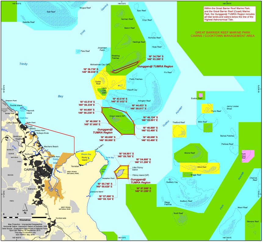
Today, Traditional Owner groups are involved in the management of their Sea Country in partnership with the Great Barrier Reef Marine Park Authority through the Indigenous Land & Sea Country partnerships program. This combines modern management with Traditional Owner knowledge to protect the World Heritage Great Barrier Reef. Along the Great Barrier Reef. A working facet of this joint management is the Traditional Use of Marine Resource Agreements (TUMRAs). These agreements are acknowledgement of the Traditional Owners to manage their Country and today over a quarter of the Marine Park coastline is managed by a TUMRA. The first TUMRA was developed by the Girringun Aboriginal Corporation in 2005, there are now 9 agreements in place across the Great Barrier Reef Marine Park. In the Cairns region the Gunggandji and Yirrganydji People have TUMRAs.
Western History
Discovery of The Great Barrier Reef
Around 400 years ago, the first European to sail the waters of the Great Barrier Reef was Luis Vaez de Torres. He commanded the San Pedro through the Northern Great Barrier Reef in 1606. After becoming separated from a Spanish expedition, he narrowly missed Northern Australia sailing through the Torres Strait which is named after him.
However, Captain James Cook recorded the first written descriptions of the Great Barrier Reef in his journal during a voyage in 1770. Aboard HM Endeavour he sailed up the east coast of Australia. On the 19th of April, Captain James Cook and his crew first laid eyes on Australia. The great southern land that was believed to counterbalance the “northern land-mass”. From here they took the unknown journey North into warmer waters. By the 9th of June the Endeavour was sitting off the newly named Cape Grafton, after passing through the channel of water between Fitzroy Island and King’s Point. Captain Cook described the area as being “tolerable high land (that) hath a very rocky surface which is cover’d with wood”. On this night the ship’s crew saw several fires on the shoreline and recorded the first sightings of the Gunggandji people. Come the 10th of June the ship was anchored off the coast near Mission Bay (Yarrabah). It was on anchor that Green Island was named by Charles Green the Chief Astronomer onboard, described as being a “low green woody island”.
Captain Cook and his company came ashore in search of freshwater but had little luck on the “surf and the rocks”. Moving from anchor, they headed further north to Cape Tribulation, where their troubles began. Cook ran aground on the 11th of June, pumping water from the hull until finding safe harbour near Cooktown on the 18th. After completing his repairs several weeks later, on the 6th of August he set sail once more. Making it to Lizard Island Cook was able to climb to the highest point aptly named “Cook’s Look”, this allowed him the vantage point to look out over the vast expanse of the Coral Sea and the Great Barrier Reef, and he determined his path away from the treacherous reefs and out to safer waters.
Naming of the Reef
The name “The Great Barrier Reef” came much later and was coined by another well-known explorer. In 1802, Matthew Flinders described the reef as “The Great Barrier Reefs”, or “BARRIER REEFS”, in his journal where a chart was attached with the name “THE GREAT BARRIER REEFS”. Matthew Flinders sailed through the Great Barrier Reef whilst surveying the Australian coastline. He navigated a passage through the inner Great Barrier Reef. Following Flinders, Phillip Parker King charted a wider passage through the inner great barrier reef in 1819 and 1820. To this day the reef is still being mapped with new technologies able to see to the reef floor and deep sea.
Captain Cook
Matthew Flinders
Research & Scientific Understanding
Following Captain Cook’s observations in 1770, scientists have studied the Great Barrier Reef in order to understand its diversity and the complex interactions it holds. Naturalists onboard survey ships were the first to conduct research on the Great Barrier Reef, followed by a wave of scientists who chartered ships to study the reef. William Saville-Kent authored the first monograph on the reef, The Great Barrier Reef of Australia: it’s Products and Potentialities in 1893.
The beginning of an approach to organised research occurred in 1922 with the establishment of the Great Barrier Reef Committee (GBRC) by the Royal Geographical Society of Australia. The GBRC aimed to “promote and conduct scientific inquiry into the fauna, flora and genesis of the Great Barrier Reef; and to protect and conserve the Reef, and to determine, report on and advise of its proper utilization.” The GBRC evolved into the Australian Coral Reef Society which is the oldest organisation in the world concerned with the study and protection of coral reefs and it has played a significant role in the nation’s history.
The Yonge expedition was another significant early contributor to the scientific understanding of the reef. Led by Sir Charles Maurice Yonge the joint British and Australian expedition took place on the Low Isles near Port Douglas from May 1928 – June 1929 and researched corals, reef life and seasonal change. Their discoveries were well publicised and produced many publications.
For research happening on Moore Reef with GBR Biology, please see our research page /research/

Image: Beche-De-Mer harvesting. Image credit: State Library of Queensland – John Oxley Library.
Industries and Settlements
Beche-De-Mer (Sea Cucumber) fisheries were one of the earliest industries on the Great Barrier Reef. The first fishery was established on what is now Lady Elliot Island in the southern Great Barrier Reef in 1804. By the mid 19th century, fisheries had moved north and processing stations were established on Green and Fitzroy Islands and Frankland Islands near Cairns. These early fisheries operated in a largely unknown and lawless GBR. At this time, the Great Barrier Reef was still largely unexplored and unsettled by Europeans and much of the Reef was still uncharted making it treacherous and difficult to sail. The Beche-De-Mer fisheries were pioneering in harsh frontier conditions, Queensland’s answer to the ‘Wild West’. The early Beche-De-Mer fishermen contributed to the charting of the reef which was still dangerous to sail through as well as exploration of the mainland
The Beche-De-Mer fishermen were among the first Europeans to settle north of Townsville, and early settlement in Cairns was driven by Beche-De-Mer fishing. Their legacy contributed to the establishment of what is now Cairns. Cairns suburb Yorkeys Knob was named after Beche-De-Mer fisherman George Lawson (nicknamed Yorkey after his home town Yorkshire) who had a processing station on Green Island and settled in the Yorkeys Knob area. George Lawson built a homestead in the Yorkeys Knob area which he used to harvest timber for use on Green Island in the curing of Beche De Mer and farmed during the off season. Yorkey lost his hand as a result of a dynamite accident while fishing at Green Island marking the end of his Beche-De-Mer fishing career.
Due to the nature of the lawless settlements, much of this history wasn’t recorded and lives on in stories. There were many conflicts between the Beche-De-Mer fishers and local Aboriginal peoples and little of this history was recorded, particularly regarding crimes committed by the European settlers. There are some records of deaths of fishermen as a result of these conflicts. There were many deaths reported on Green Island throughout the 19th Century. Beche-De-Mer fishing also relied heavily on the labour of First Nations People who were likely mistreated or exploited.
Subsequent early industries followed Beche-De-Mer fisheries increasing the settled population. These included gold mining, red cedar logging, cane farming and other agricultural practices. Towards the end of the 19th Century the settlement of Cairns was named a town and the population and industries have continued to grow. Today, one of the biggest industries on the Great Barrier Reef is Tourism, with over 2 million visitors a year it is the 4th largest economic contributor to the economy.
Early Tourism
Tourism on the Great Barrier Reef was made more accessible by technological advancements after World War II and began to emerge as a vital industry. Prior to this, tourists were typically taking part in chartered naturalist expeditions, pleasure cruises or visiting early holiday resorts. The campaign to be the “playground of the nation” began and new ways of seeing the reef while staying dry such as glass bottom boats floated out on the reef 1930’s-40’s. The first ever on Green Island. Tourism practices have also evolved in the last 100 years going from exploitative activities such as shell collecting, turtle riding and dugong hunting to snorkel and dive operations practicing good reef etiquette in only taking photos and leaving nothing behind.
In 1975 the Great Barrier Marine Park Act was passed as a result of a long public campaign against oil drilling on the reef. The act established the Great Barrier Marine Park Authority, responsible for managing the Marine Park and the first sections of the park were declared in 1979. Since then, the park has gradually increased in size. The area of the Great Barrier Reef Marine Park is larger than New Zealand or the United Kingdom, equivalent to 70 million football fields (345,000 KM2).
In 1981 the GBR was included in the United Nations Educational, Scientific and Cultural Organisation (UNESCO) World Heritage List. The Great Barrier Reef met all four criteria that can apply to a reef system. These were:
- “to contain superlative natural phenomena or areas of exceptional natural beauty and aesthetic importance”
- “to be outstanding examples representing major stages of earth’s history, including the record of life, significant on-going geological processes in the development of landforms, or significant geomorphic or physiographic features;”
- “to be outstanding examples representing significant on-going ecological and biological processes in the evolution and development of terrestrial, fresh water, coastal and marine ecosystems and communities of plants and animals;”
- “to contain the most important and significant natural habitats for in-situ conservation of biological diversity, including those containing threatened species of outstanding universal value from the point of view of science or conservation.”
This inscription recognised the immense diversity and importance of the Great Barrier Reef. In 2004 a comprehensive zoning system was developed and introduced to the management of the Great Barrier Reef Marine Park. This system was designed for the sustainable use and protection of the reef. The GBR is split into four major management areas and each of these areas contains various zones dictating the type of activities that can be carried out. There are eight zone types which include General Use, Habitat Protection, Conservation, Marine National Park and Scientific research areas. As the Great barrier reef is such a large and diverse area a complex and multifaceted approach is required to effectively manage and protect its ecosystems.


Our History
The Beginning
Reef magic cruises began in 1997 running out of Yorkeys Knob, issued with a roving tourism permit to visit different reefs daily. The company had approximately 30 reef sites and started visiting the Moore Reef site on Gunggandji Sea Country in 1998. Located approximately 45km from Cairns the site has ideal water conditions with high coral covers and rich diverse assemblages. In 2004 Reef Magic acquired the last permit issued for a tourism pontoon under the Cairns Area Plan of Management and Marine World was created. Following this, Reef Magic began visiting Moore Reef Marine World daily and only used the other reef sites for specialised charters. Until 2018 when Dreamtime Dive and Snorkel was born and started to utilise these sites daily which are situated on Yirrganydji and Gunggandji Sea Country.
Foundation for Research
With the birth of Marine World in 2004 the marine biology team became very popular for delivering highly informative and engaging snorkel tours. The storytelling developed to a more comprehensive approach that showcased our extensive site knowledge and high understanding of animal behaviour. This became the foundation for research projects into fish aggregations and crown-of-thorns starfish research at Moore Reef. We have the most comprehensive fine scale study of a fish aggregation site in the world.
The Birth of Reef Education
In 2014 our Reef Education department was created to promote the GBR as a classroom for local primary and secondary school students. The learning focus was on the biological and Indigenous perspectives of the GBR. Today we have a large team of biologists and Cultural guides that take 1000’s of Australian school children every year to a diverse array of coral reef sites.
In 2019 the marine biology department was formalised into our department GBR Biology with the vision to promote Marine Science and Indigenous Culture in Tourism. These values are well represented in the new pontoon “Remoora” and showcased by our very own Marine Laboratory floating on our beloved Moore Reef and represents the practice of 21st century conservation values.
Sources
- A thousand Miles Away, A history of North Queensland to 1920 by GC Bolton (1991) Expedition to the Great Barrier Reef 1928-1929 – Part 1 – JCU Library
- History of Cairns from the 1870s. Cairns Regional Council
- Indigenous Cultures and Contact History: Timeline, Australian Museum.
- Narrative and reports of the Queensland North-East coast expedition, 1873 by GE Dalyrmple (1874)
- The Great Barrier Reef: A Queensland Museum Discovery Guide (2013)
- The Great Barrier Reef in Time and Space: Geology and Palaeobiology The Great Barrier Reef: Biology, Environment and Management(2018)
- The Great Barrier Reef of Australia: Its products and potentialities by William Saville Kent (1982)
- The History of Green Island by Dorothy Jones (1976).
- The town that was drowned: some North Queensland memories and anecdotes. Journal of the Royal Historical Society of Queensland by Clem Llewellyn Lack (1971).
- 20 000 Years Ago, Australian Institute of Marine Science.